

The Geomorphologist
A simple way to talk about my study researches, my subject of predilection...
my approach of the morphogenesis and the landscape evolution.
2000 - 2007: Time of university

A geographic, geomorphologic, ecologic and human path
I learned geography and geomorphology in Aix-Marseille University. My professors were Mireille Provansal (fluvial sedimentology), Maurice Jorda (Glacial, Lateglacial and Holocene torrential dynamics, also my mentor), Christophe Mohrange (littoral dynamics). My director was Cécile Miramont, specialist of Lateglacial torrential dynamics and dendrochronology.
During my late studies, I was assistant professor at the Geography department in Aix-Marseille University, and integrated in the Ecology and Paleo-ecology Mediterranean Institute (Ex-IMEP, now IMBE).
During all this studies, I learn History, Archaeology, engineering of Ecology, Palynology and Anthracology too.
A sandbox : the french south Alps.

In the natural history of the french south Alps paleolandscapes, the Postglacial* morphogenesis concept is definitely essential.
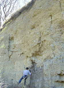
In french south Alps, most of adret torrential glens have a similar landform: thick alluvial deposits, from 10 to 25 meters. This deposits are naturally notched, slashed by actuals torrents, which gives a closed glen environment. By means of these slash, the postglacials deposits (from 15.000 to 6.000BP in average) are revealed. By studying their sedimentary profiles and biological contents, we can rebuilt the landscape history from the removal of the regional main glacier.
*Postglacial : Bolling-Alleröd to Atlantic period. A invented term by M. Jorda. In Memoriam...
More than 15.000 years of landscape history
These 15.000 years of landscapes history are invaluables archives to an understanding and modelling of the Erosion dynamics.
Rhythmicity. Far from being settled and equals all along the millenaries, rhythmicity is characterized by jolts, accelerations and decelerations. Jerks are named "forcings" in geomorphological therms. They are linked with punctually climatic events, like storms or thunderstorms. Decelerations are linked with sweet and equal climatic periods. During these periods, the forest settles in the glen backgrounds, and the slope become gentler. Torrents flows quietly, the sedimentation is more vegetal (limestone granulation, peat).
In more active periods, the forcings, sedimental archives register flash floods: glens are filling by floods sequences, the forest is destroyed or stifled by the heightening of the surface.
The main issues, in the contest of my researches, are to know if forest fires (naturals or anthropics) played a role in this rhythmicity.
What kind of relationship between torrential sedimentary dynamics and forest fire ?
Working around this researches topic (still in the exploratory stage yet), requires for an information collection more broader than the only geomorphologic one. Before the human sedentarisation, Erosion rhythms are essentially climatics and geometrics.

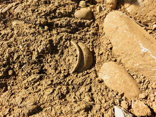
Everything depends on the disposition and availability of materials, precipitation rhythm and vegetation. We say that morphogenesis is natural. We can see this rhythms in torrential deposits, but in sub-fossil tree trunks and charcoal deposit too. Some stratigraphic junctions are burned, reddened. There are followed by a dynamical increase that we see in sediments by a rise of ballasts and/or sand fractions. Climatic cinematic may be exposed by pollens and charcoal determination if it's possible.
Human sedentarisation start, in this landscape, around 6.000 BP years, exactly when there is a step in morphogenesis. Landscapes are non-dynamics, torrents are sweets and regular, like climate. Archaeological artefacts allow the detection of human presence and activities. Palyniologicals records, in wetlands (bogs and lakes), show us the beginning of deforestation. And humans began the deforestation with ... fire. Since then, morphogenesis is not only natural: it's human too. Environments change with "climato-anthropics" jerks.
How do we make the link between fires and morphogenesis? With a binocular magnifier and 4 sieves. We count charcoals. We determinate sedimentological profile. And we got this kind of record.
fifteen years later ...

...Practice time, in the real world
My actual activity is to provide geomorphology in the archaeological environment. I work with a national group of preventive archeologists, the "Service Départemental d'Archéologie" (i.e. council-like archeological department) in Alpes-deHaute-Provence, Vaucluse and PACA région.
Between professional soap-making and picking wild medicinal plants, I carry out targeted paleo-landscapes analyses on emergency excavation sites. This kind of work is very different as the scientific research, as it must provide quickly and efficiently response to questions about local anthropic occupations.
A new sandbox : Digs and excavations.
The variability of the land to be analysed is very high in this researches context. The work is no less interesting: it's a permanent challenge to adapt. Each site has its own history which must be linked to a wider spatio-temporal context.
Mainland analysis for archeological diagnostics consist to recreate a landscape context and a succession of paleo-landscapes in specified periods. Paleolithic, Neolithic, Bronze age, Iron age, Antic or Middle-age ... historical periods follow each other. Each has a climatic and morphodynamic context, but indices are sometimes really weak. Weak, for a geomorphologist is 15cm. 15cm for 6.500 years. Oui Monsieur.
Knowledge of the actual landscape and that rythmes helps to pitch together the pieces, like the archaeologist makes on a fragmented pottery. Assumptions regarding anthropisation possibility and desertion must be made, in regard with the local morphogenesis. If there is a connection, of course.
Lastly, it's important to design an assumption for the fossilisation. For many, it's clearly morphodynamic. And this last idea allows us to know how deep the rest of the artefacts will be.
Sometimes, archeological digs time is coming. Analysis are then more refined, more slow:
we can have time for a better comprehension, a smarter design.
Surveyings
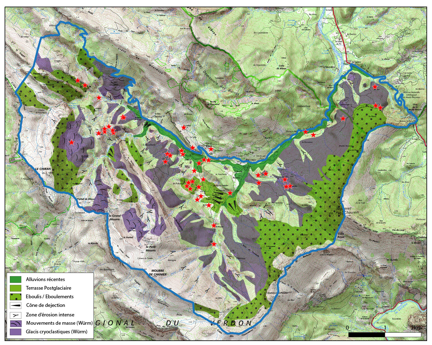
Another way to work with archaeologists is survey. The geomorphologist who's inside me is fulfill: an area, a valley, a ridge, a full landscape. The apprehension is different, because it's purely geographical. The landscape elements work with all other in a wide landscape. The preferential treatment is cartographic. It's a big work but which bring, here again, an invaluable assistance for my dig's mates. Moreover, the landscape reading and it understanding is done in real time. Archaeological prospections are then headed in the more suitable environments for surface discoveries.
How can the geomorphologist's eyes detect the "more suitable environments" ? Thanks to a simple reading of the landscape dynamics. For example, Holocene dynamics have created, in mountain, some flat and drained areas. These paleo-terraces (alluvial cones in fact) have been choice's places for human establishments between 6.000 to 2.000BP.


actual points of interest
- Anthropisation and landscape dynamics
-
- Anthropic pressure on landscapes and paleolandscapes
- Vegetation / re-vegetation
- Climate change impact
-
- Climate change and adaptation of societies
- Climate change and dynamics of landscapes
- Climate change and fire rules
- Landscape ingeneering
-
- adjustments challenges of societies to climate change
- Sedimental archives
-
- Predicting the future through the past
- Landscapes analysis
-
- Provence Alpine and Subalpine
- Scotland (Borders, Coastlines, Highlands)


geomorphologic speciality
- Landscapes :
-
- Highlands / Mountains
- Collinean
- Alluvial / Fluvial
- Cave
- Wetlands
- Dynamic of Erosion :
-
- Torrential
- Glacial / Periglacial
- Alluvial
- Peat bog / Lacustrine
- Pedology
- Hillsides
- Themes and favorites subjects :
-
- Postglacial Morphogenesis (Tadiglacial to Holocene, Anthropocene)
- Landscape dynamics following forest fires (overall / local / in-situ / micro. Paleo and Actual)
- Dynamics of forest fires
- Anthropic pressure on natural landscapes
- Anthropisation and landscape relationships (actual, paleo). Specialisation for Neolithic to Middle-Age.
- Method of investigations:
-
- Landscape reading (macro-observation)
- Sampling
- Granulometry
- micro-observation
- Bibliography
- Archival research
- Communication:
-
- Cartography (topo, geology, geomorphology, morphodynamics).
- Design (Illustraor, Qgis)
- Photography (image analysis)
- Scientific report
- Lecture

publications
C. Boutterin (2002). Le facteur feu dans la morphogenèse postglaciaire des Alpes du Sud: le versant sud de la montagne de St Genis, approche pluridisciplinaire. Mémoire de maitrise (C. Miramont dir.), Université d'Aix-Marseille.
C. Boutterin (2003). Les feux et la morphogenèse postglaciaire dans les Alpes du Sud: la région de Lazer (Hautes-Alpes). Mémoire de Diplôme d'Etudes Approfondies (C. Miramont dir.), Université d'Aix-Marseille.
C. Boutterin (2007). Feux et forçage morphogeniques postglaciaires dans les Alpes du Sud: une approche pluridisciplinaire dans le complexe Buëch-Durance. Thèse de doctorat (C. Miramont dir.) (non soutenue), Aix-Marseille Université.
T. Castin (dir.) (2022). Grottes du Galetas. Rapport de fouilles archéologiques, SRA PACA (département 04).
P. Marrou, M.Serieys, C. Boutterin, A.-M. Curé, D. Delpalillo, R. Roure (2022). Le Mourre de Sève (Sorgues, 84), Rapport intermédiaire
d'opération 2021. Projet collectif de recherches, SRA PACA (département 84), dossier n°13187.
J. Seleque, C. Boutterin, A. Lattard, N. Toutain (2021). Riez Pont-Jacquet, Bilan Scientifique. DRAC PACA, SRA, Ministère de la culture et de la communication,
direction du patrimoine, sous-direction de l'archéologie.
E. Henrion (dir.) (2021). Cimetière Juif de Manosque. Rapport de fouilles
archéologiques, SRA PACA (département 04).
J. Seleque, C. Boutterin, A. Lattard, N. Toutain (2021). La Cassine, Peyruis. Bilan Scientifique. DRAC PACA, SRA, Ministère
de la culture et de la communication, direction du patrimoine, sous-direction de l'archéologie.
C. Boutterin (2021). Comment la géomorphologie apporte son grain de sable : l'approche paléopaysagère, SRA PACA (département 04),
musée archéologique de Quinson.
J. Seleque (dir.) (2020). Digne Borrely. Rapport de fouilles archéologiques, SRA
PACA (département 04).
A. Morin, C. Boutterin, C. Miramont, O. Sivan (2019). Le 4° et le début du 3° millénaires av. J.-C. dans les Préalpes: quelques résultats des recherches pluridisciplinaires engagées dans les vallées du Buëch et de la moyenne Durance (Htes Alpes, France). In: Actes de la Table ronde : Quatrième Millénaire – Du Néolithique moyen au Néolithique final dans le sud-est de la France et les régions voisines.Aix en provence, juin 2005.
M. Dupuis, S. Bezault, C. Boutterin (2015). Castellane, Gymnase Notre-Dame. Bilan Scientifique. DRAC PACA, SRA, Ministère de la
culture et de la communication, direction du patrimoine, sous-direction de l'archéologie.
C. Boutterin (2013). Des manifestations du temps dans le paysage. Discussion autour de la perception du géographe, in : Usages du temps en sciences humaines et sociales: méthodes et questionnements, Ouvrage collectif.
O. Sivan, C. Barra, C. Boutterin, M. Buiron, F. Sumera, M. Vecchione et al. (2008). "Salvage Archeology and Geoarcheology: the example of the coastral margin
between Antides and Nice (France)". In: Reconstructing Human-Landscape Interactions, Cambridge Scholars Publishing.
C. Boutterin, C. Miramont, S. Muller, J.-L. Edouard (2008) Postglacial paleofires and morphogenic expressions in a torrential rainfall catchment area of the southern french Alps : the Mardaric (Hautes-Alpes, France), in: Géomorphologie, num. spé. « feux et érosion » sous la direction de J.-F. Berger.
C. Boutterin, C. Miramont, S. Muller, J.-L. Edouard, S. Valleteau (2007). Le rôle du feu dans l’histoire des paysages sud-alpins de moyenne montagne entre 12000 et
7000 ans BP, Approche méthodologique. In: Actes du colloque RTP « Paysage et environnement: de la reconstitution du passé aux modelés prospectifs », Chilhac,
septembre 2006.
S D. Muller, T. Nakagawa, J.-L. de Beaulieu,M. Court-Picon, C. Carcaillet, C. Miramont, P.Roiron, C. Boutterin, A. Ali and H. Bruneton (2007). Post- glacial
migration of silver fir (Abies alba Mill.) in the south-western Alps, in: Journal of Biogeography 34, 876–899.
C. Boutterin (2006). Implication des feux dans la morphogenèse postglaciaire sud-alpine, in : ACI Valbonne sous la présidence de J.-F.Berger, Sofia Antipolis, Janvier 2006.
C. Boutterin, C. Miramont, S. Muller, J.-L. Edouard (2005). Le rôle du feu dans l’histoire des paysages méditerranéens sud-alpins de moyenne montagne. Exemple de la
dépression de Lazer, in l'érosion entre société, climat et paléoenvironnement, table ronde en l'honneur du professeur René Neboit-Guilhot, Clermont Ferrand, mars 2004, Presse
Universitaires Blaise Pascal, coll. Nature & Sociétés, pp. 393 – 400.